
In the eastern and central parts of the Pacific Ocean warm waters are creating an El Niño event, predicted to be stronger than those of past years. For the southwestern U.S., this brings hope of a wet and snowy winter.
Although El Niño events bring storms to the area, El Niño itself is a climate phenomenon, not simply weather or a storm. In the Southwest, particularly Arizona, El Niño is a factor within the study of climates.
“When you work in the Southwest and you are a climate person, the biggest game in town is El Niño,” said Mike Crimmins, a climate science extension specialist at the UA Department of Soil, Water and Environmental Science. “On climate time scales, it is the biggest player as far as controlling year-to-year variability and increased precipitation.”
What is El Niño?
Beginning its development last spring, the current El Niño showed little effect on the monsoon season. An El Niño event will span across years and the changes in sea surface temperatures, which prompt El Niño, occur every two to seven years.
According to the Climate Assessment for the Southwest’s El Niño frequently asked questions, El Niño conditions are predicted by looking at the atmosphere, the ocean and sometimes a combination of both. Sea temperatures are one of the largest indicators of whether there will be an El Niño event. According to Crimmins, these temperatures contribute to the oscillation between La Niña conditions, neutral conditions and El Niño conditions. La Niña is characterized by cooler temperatures on the ocean’s surface while El Niño is associated with higher temperatures, according to the National Oceanic and Atmospheric Administration’s website.
The Oceanic Niño Index is used to track sea temperatures. The range of ONI values goes from -2.5 to 2.5, with 2.5 being indicative of a strong El Niño event and -2.5 being indicative of a strong La Niña event. When the ONI value is .5 for at least five consecutive months, climatologists can predict the emergence of El Niño conditions. This year’s predictions are forecasting a strong El Niño, with ONI values greater than 1.5.
“The big El Niños are [those of] 1982-1983 and 1997-1998, and by some metrics, we’ve already exceeded the strength of those events,” Crimmins said. “We will just have to see how the rest of the winter plays out.”
How will Tucson Experience the El Niño?
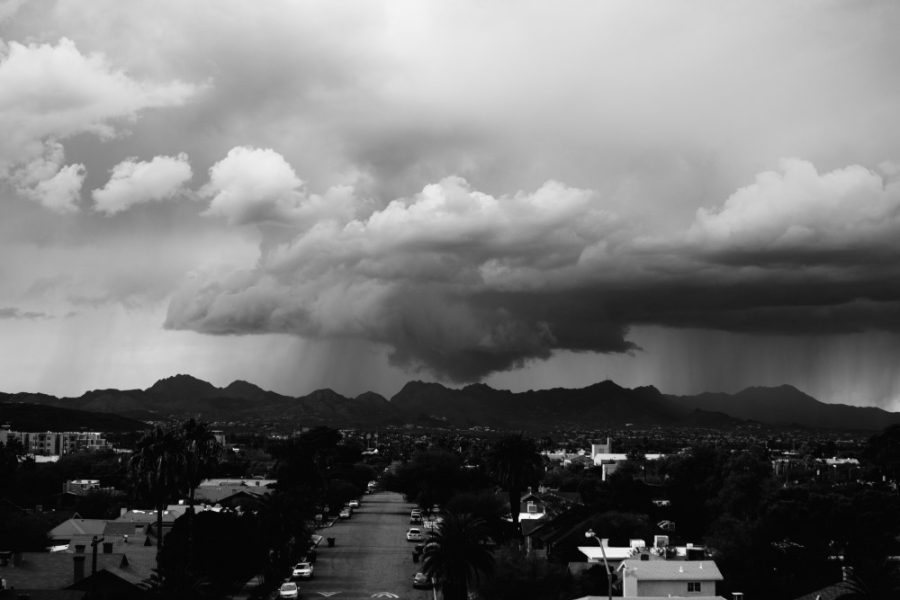
Climatologists are already beginning to see some effects of this year’s El Niño in the form of tropical storms. Patricia, a large tropical storm spotted off the coast of Mexico in mid-October, was influenced by El Niño conditions. Further, according to Erika Gallo, a watershed hydrology instructor in the UA School of Natural Resources and the Environment, much of the unusual fall rain Tucson has been experiencing stems from the weather anomalies created by El Niño.
“We have already experienced [the anomalies] a little bit with a particularly wet fall,” said Gallo. “We never had that break where we have a distinct break in monsoonal rain and then have the start of fall and winter rain.”
For Tucson, the predicted precipitation and snowfall from El Niño will mainly influence the ecological environment and stream flow. Short-term drought conditions are already improving, with more moisture available in the soil. Water-starved trees may begin to bounce back and the spring is poised to have substantial wildflower blooms.
“Plants will be, I think, quite happy, and trees, which have been stressed from 15 years of drought, may start to respond and come back from the brink,” Crimmins said.
Tucson water basins may also have more sustained water flow, according to Gallo, with influxes coming from the Catalina Mountains, the Rincon Mountains and the Sabino Canyon area.
“We are probably going to see more stream flow, which would be kind of fun to see some of these femoral washes with more sustained flow,” Gallo said.
El Niño will not significantly impact the long-term drought, however. Groundwater conditions in Tucson may not change much, since most of the precipitation from El Niño will not make it into the ground water. The Colorado River will also not see much uptake either.
What can students expect to see?
Unlike with the monsoons, the rainfall events of this El Niño year are likely to be long-lasting. Since this El Niño is predicted to bring warm and wet conditions, Tucson should expect more rainfall than usual. If temperatures take a turn to the colder side, however, there is a chance of snowfall at lower elevations.
“It might be a little bit of a nuisance for students to walk to class, because of the way in which our El Niño storms come in,” said Gallo. “They are these long, frontal extended systems, so they last a long time.”
Since the rainfall seen with El Niño is experienced over a prolonged period of time, flood risks are not as high as during the monsoonal periods. However, the nature of desert makes Tucson flood-prone to begin with.
As with all climate phenomena, it is important to understand that the effect of El Niño can only be predicted to a certain extent. The real effects of this year’s El Niño conditions will be seen in the spring, when the clouds dissipate and the wildflowers bloom.
Follow Natalie Robbins on Twitter.