
Over 106,000 Arizonans will participate in an international earthquake preparedness drill, the Great Arizona ShakeOut, on Oct. 19 at 10:19 a.m.
Arizona is just one of 30 other states that will practice their earthquake preparedness during the ShakeOut. A total of 14.1 million people will be participating in the U.S. and more than 52.3 million people across the world, according to the Great Arizona ShakeOut website.
Anthony Cox, deputy director of the Arizona Emergency Management Department, said this program is just one small part of Arizona’s emergency response and recovery plan.
“Our state emergency response and recovery plan exists to give us structure for how we [give] support, in coordination to the 15 Arizona counties and their emergency management departments, as well as partnership with the sovereign tribal nations of Arizona,” Cox said.
Students, federal employees, tribal communities, health facilities and businesses will practice earthquake preparedness. Arizona has hundreds of earthquakes a year, according to the Arizona Department of Emergency and Military Affairs website.
“ShakeOut teaches the public … easy-to-understand steps to stay safe like the Drop, Cover and Hold On campaign that Arizona Geological Survey has been promoting,” Cox said.
The campaign teaches that when an earthquake happens, first drop to the ground, then take cover under a sturdy structure in a room to protect your body and hold on during the entirety of the earthquake.
RELATED: Feeling SAD this autumn?
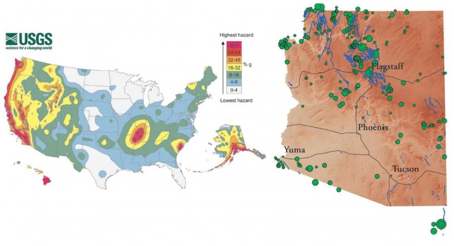
Some cities require more attention for earthquake preparedness. More earthquakes occur in Prescott and Flagstaff on the northern plateau of Arizona, according to the Arizona Geological Survey website, as well as the city of Yuma in southwest Arizona.
“We encourage residents of Arizona and visitors to be ready for all disasters,” Cox said. “Building an emergency supplies kit and writing a family communication plan [is important]. People are better off to help themselves in the initial offset for whatever emergency they could face in their community.”
Yuma has the largest potential for earthquakes because it one of the nearest Arizonan cities to the San Andreas fault in California.
“The San Andres strike-slip fault is the most worrisome for Arizonans, even though it only has shallow earthquakes that begin from two kilometers from the surface,” Michael Conway, senior research scientist at Arizona Geological Survey said.
According to the U.S. Geological Survey website, strike-slip faults are vertical fractures where the tectonic plates mostly move horizontally.
Earthquakes are measured two ways: In magnitude, based off the amount of energy released, and also by intensity, which is how the earthquake specifically impacts people, according to Conway.
“In Yuma, the water table is higher and the groundwater makes the sediment softer,” Conway said. “Buildings on this type of sediment may not fall entirely, but start to topple and tip as [they] sink into the ground during quakes.”
Arizona also has faults that are worrisome in terms of potential earthquake magnitude. The Santa Rita fault zone, west of Santa Rita Mountains, is only 40 miles from Tucson and is able to produce a 7.0 magnitude earthquake, according to the Arizona Emergency Management and Military Affairs website.
“A magnitude 2 earthquake compared to a 3 is a difference of 30 times,” Conway said. “A magnitude 3 quake to a 4 is a 900-time difference in energy.”
RELATED: The flow of what’s below: A million dollar idea
Duncan, Arizona experienced a 5.3 magnitude earthquake in June 2014, with thousands of aftershocks. Aftershocks can occur weeks, months and even years after large earthquakes, as Earth’s crust slowly settles, according to the Arizona Geological Survey repository.
“Magnitude 2 to 3 earthquakes are qualified as felt earthquakes,” Conway said. “Sometimes, aftershocks can be more harmful than the original earthquake.”
The highest-magnitude earthquake Arizona has experienced in recorded history happened in 1887. The 7.6 magnitude earthquake caused major rockslides that kicked up so much dust citizens at the time believed it was smoke from forest fires, according to the Arizona Geological Survey repository. The earthquake’s origin, or epicenter, was 40 miles southeast of Douglas, Arizona, on the Pitaycachi Fault.
One problem is that old town and historical districts in Arizona’s cities are expensive to retrofit to hold up for earthquakes, according to Conway.
“Most building inspections are handled locally at the municipal level,” Cox said. “We do partner with organizations that center on structural integrity and post disaster effects when they occur.”
Seismologists, who can tell you when buildings aren’t constructed properly for earthquake safety, and Arizona Geologist surveyors work together to make information available online for the public. The information is updated in the event of any Arizona natural disasters, according to Conway.
RELATED: The hormones that may be making your dog aggressive
The U.S. Geological Survey also has a crowdsourcing website for reporting when and where earthquakes are felt nationwide called “Did You Feel It,” and Arizona has its own methods for detecting earthquakes.
“The Arizona Broadband Seismic Network is an interconnection of 12 devices placed statewide plus the four devices placed by the United States Geological Services,” Conway said.
According to Conway, the Arizona Geological Survey is currently working with Mohave and Yavapai counties, helping them to be alert when many smaller magnitude earthquakes occur. That’s important, Conway said, because it commonly indicates that a larger magnitude earthquake is coming.
Cox said that campaigns like the Great Arizona ShakeOut helps communicate earthquake preparedness tips on a wide scale, which is useful.
“[Arizona Emergency Management Department] supports Arizona Geological Survey and this ShakeOut campaign to communicate and spread the word about this hazard,” Cox said. “We use the online platforms and social media to register and participate in the drill as well as learn about other hazards and personally prepare for earthquakes.”
Follow Olivia Jones on Twitter